Wednesday, 1 February 2012

Brrrr!!

It has been a bit chilly today to say the least, and this map from the Met Office shows that there are warnings of severe cold weather in place across much of the country.


The cause of the cold weather is the high pressure system that is currently sitting over northern Russia...


Surface pressure chart


The Year 8 geographers have been looking at air pressure and how it affects the weather, so they should be able to tell you all about what's happening at the moment.


However cold we might think it is here though, we come off pretty lightly... Temperatures in eastern Europe have reached -32oC in places, Hungary is experiencing the lowest temperatures it's seen in 65 years, and more than 70 people have died as a result of the cold temperatures.

There is a fantastic set of photos here of the coast of Romania, where the Black Sea is frozen!!

Friday, 30 September 2011

Montserrat

The Year 9 geographers have been having a look at Montserrat in their geography lessons this week... The Montserrat Volcanic Observatory have just posted this lovely photo on their Facebook page... Click on the photo to link to the MVO website.

Friday, 5 August 2011

London 2 London

I've just come across this very interesting sounding expedition via Twitter. Sarah Outen left London on 1st April 2011 and her plan is to travel all the way round the world and back to London using only her own power - three continents and two oceans by boat and bike!


Check out Sarah's expedition website here. You can also follow Sarah's progress via Facebook and Twitter.

Thursday, 4 August 2011

Move...

Fantastic video via @al_humphreys... Probably coming to a Geography lesson near you in September!

MOVE from Rick Mereki on Vimeo.

Saturday, 23 July 2011

GROW

Nice video to launch Oxfam's new food security campaign.


Click here to find out more and get involved.

Tuesday, 12 July 2011

Summer Geography Competition

Wherever you are heading over the summer holidays, keep an eye out for all things geographical so that you can enter our lovely competition...

The competition is open to all students who will be in Year 8, 9, 10 or 11 in September, and there'll be a prize for each year group.

Your challenge is to create a collage of your geographical summer holiday. You might want to include maps, photographs, tickets, objects.... from places you visit. It doesn't matter whether you're going to Crich Tramway Museum or the Great Wall of China, and your collage can be based on a day, a week or the whole summer holiday.

Entries will be judged on creativity, imagination and geographical-ness...

Your entry needs to be handed to Miss Ellis in H7 by the end of the day on Friday 9th September, and must be clearly labelled with your full name and your [new] form.

Have fun!!

Saturday, 9 July 2011

A new nation

The Guardian has its version of 'the new world map' here. It's new because it includes South Sudan - the world's newest country as of today. You can read more about South Sudan from the BBC here and on the Worldmapper blog.


Sunday, 19 June 2011

Young Geographer of the Year 2011

Could you be the RGS's Young Geographer of the Year 2011? Click on the flyer below to go to the RGS's website where there are more details about the competition and what you need to do.

Sunday, 12 December 2010

Where the hell is Matt?

The Year 8 geographers have enjoyed watching "Dancing Matt" and finding out more about the huge range of places that he's visited.

You can find out more about Matt and his dancing on his website - but there are one or two rude words on there... you've been warned!

This is where it all began:


The first video sponsored by Stride:


And the second:


And most recently, in the run-up to the World Cup, Matt danced the Diski around South Africa:


For their homework this week, my Yr8s were asked to think about where in the world they would most like to dance with Matt and why... Here are the first two:

Charlie: The place I would like to dance with Matt is Paro, Bhutan because the scenery is very nice and it looks very interesting because all of the different colours.

Regan: I would dance with Matt in Andorra, because the views and heights make Andorra very relaxing in the summer. It is a very warm place in the summer and a very cold place in the winter. Andorra is well known for all the snow in the winter, the heights make Andorra very good for winter sports and the snow would make the views even more special.

Interesting choices gentlemen - I'll add some more as they arrive... And if you're not in my Yr8 Geography group, leave a comment and let us know where YOU would most like to dance with Matt, and why!

Thursday, 2 December 2010

#UKSnowDepth

Following on from the #uksnow map started last year, Tom Barrett has set up a UK Snow Depth map... Measure the depth of your snow, and add it to the map:


View #UKSnowDepth in a larger map

Snow!!

If you're getting bored (?!) of sledging and snowman-building, have a go at one of these geographical snow challenges:

1. Measure the depth of undisturbed snow in different places - how and why does it vary?

2. Collect a cup of snow... Bring it inside and let it melt. How much water does it produce? Is this more or less than you expected?

3. If you have a thermometer at home, keep a record of the temperature... How does it change? Why? Keep a record of the times when it’s snowing... Watch the sky and how it changes... How do the temperature, the weather conditions and the state of the sky relate to each other?

4. Choose a particular spot – somewhere in your garden... or out of your bedroom window. Take a photo every hour. Put them together in MovieMaker to make a timelapse movie... (Email me the finished product, or upload to Vimeo or YouTube and email me the link.)

5. Wrap up warm and put your wellies on... Then go for a walk. Put together a snow/ice/cold weather hazard map for your local area.

6. Find some black paper and freeze it. When it snows again, take your frozen black paper outside and catch some snowflakes. Look at them carefully (with a magnifying glass if you have one). Describe them. Have a go at taking some photographs of them.

7. Make a glacier... Send me photos and/or video...

8. What does the snow look like? Feel like? Smell like? Sound like? (Taste like? H&S!!)

9. Make a geographical sculpture... The Eiffel Tower? The Taj Mahal?

10. Make some icicles or freeze some bubbles...

11. Go follow some footprints in the snow... Who or what made them?

12. Make a Frozen Earth video - Grace in Yr11 made a fantastic Urban Earth style video in January, taking photos every 8 steps on a walk through her snowy village... Upload it to Vimeo or YouTube and email me the link.

13. Something else!!! Can you come up with your own interesting educational snowy geographical challenge?

Tuesday, 30 November 2010

Snow Missions...

I've posted a few times about the excellent Mission: Explore... but now there are Snow Missions! Try some of them out and leave a comment or send me an email with your evidence Or have a go at creating your own snow mission...

If you're a Twitter type, search #SnowMission...

Sunday, 31 October 2010

Work for 8D

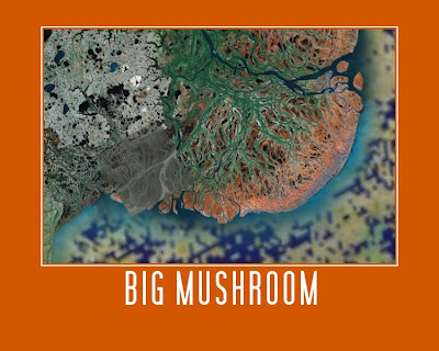
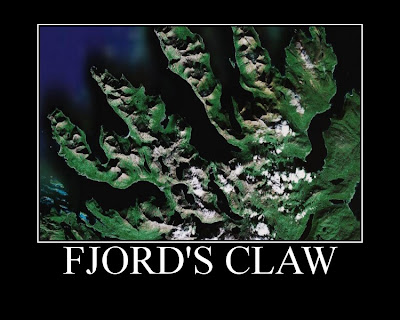
Good morning 8D! I'm sorry that I am not there for your first lesson back... However... Your challenge for today is to use Google Earth to produce a fantastic piece of art work... Below are two of my favourite examples from Year 8 groups over the past couple of years, and you can see some of the others by clicking here.


To make your own...
1. Open Google Earth (Start, Swanwick Hall, Humanities, Google Earth).
2. Spend some time exploring, and find yourself a beautiful view.
3. Open a new Ppt presentation.
4. Back in Google Earth, make sure you are happy with your view - do you want to zoom in or out, or tilt it? You'll probably also want to turn several layers (Gallery, Panoramio, Borders and Labels, etc. off - do this towards the bottom of the sidebar on the left - this will remove "clutter" from your view), then take a screenshot (hold down Ctrl + press PrtScn).
5. Paste your screenshot into your Ppt slide.
6. Crop your screenshot until you are happy with it.
7. Right-click on your picture, and select "Save as picture..." Give your picture a sensible name, and save it in your user area (preferably in a Geography folder!). Check that the filetype (in the dropdown box below where you type the filename) is .png or .jpg.
8. Go to the Big Huge Labs website. Upload your picture, and then experiment with colours, etc. and give your work a caption.
9. When you are completely happy with it, click Create. Once your finished poster appears, you can either go back and edit it, or click Save. Save the file to your computer, giving it a filename that includes your name.
10. Open your school emails. Type vel into the address bar, and then attach your finished work (not the screenshot from your ppt). Send!

I am expecting AT LEAST one brilliant piece of work from each of you, and we'll have a look at everyone's work when I see you on Tuesday.

Good luck and have fun! Miss Ellis :)

Oops!

Not sure what has happened that has meant it's half a term since my last post here.... Especially when there have been lots of geographical bits and pieces to be blogging about... Some updates coming in the next few weeks.

Friday, 20 August 2010

Congratulations!!!

Yesterday was A Level Results Day, and the Year 13s achieved the best A Level Geography results that there've been during my time at Swanwick (and quite possibly before that too!)... all nine of them got C grades or above!

They were the first cohort to go through the "new" A Level course, and this was the first year that it was possible to achieve an A* grade at A Level. And two of the geographers - Jo and Michael - did just that!! (Their A*s were two of only seven in the school!)

Well done Year 13 (and I guess that makes you officially "the best A Level Geography group"!!) - very best wishes for the future, whatever you are doing (even if it's not a Geography degree...).

Thursday, 5 August 2010

Map Addict


I have just finished reading Map Addict by Mike Parker which (as well as making me realise I am not quite so obsessed with maps as I could be) was a brilliant read - full of interesting geography, history and stories that make you nod and smile in an "I know just what you mean" sort of way. Click on the picture for the Amazon link.

Disclaimer - there are some rude words in it.

Saturday, 31 July 2010

West Yorkshire in Ten Squares

I was interested to read an article in the Yorkshire Post this morning about Alan Burnett, a blogger (and formerly lecturer, writer and bus conductor), who grew up in Yorkshire and is now three weeks into a project in which he is exploring, photographing and writing about ten randomly selected grid squares in a West Yorkshire road atlas.

I'm possibly a little bit biased, having grown up in West Yorkshire myself, but Alan's blogposts of the project so far - Little Germany in Bradford, Ilkley Moor, and Woodlesford (of which I had never heard) make very interesting reading, and I'm looking forward to seeing where he goes next...

West Yorkshire in Ten Squares

And as I was writing that, the fourth instalment's been added... Grid square 4 was Calverley, just down the road from my parents' house, and where one of my best friends from school used to live.

Friday, 30 July 2010

Fault-Line Living

On Saturday, the Fault-Line Living team will set off on their 15,000 mile expedition from Iceland to Iran, to investigate the stories of people living on faultlines. The expedition is sponsored by the Royal Geographical Society and Landrover, and the team will be carrying seismometers provided by the BGS with them.

The expedition website is here and you can also follow their progress on their Facebook page.

Monday, 26 July 2010

Mission: Explore!

Not the first time I've mentioned Mission: Explore, but as well as the brilliant book (if you haven't bought it, you should) there's now an iPhone app - Mission: Explore London. The app contains a variety of missions located around London, and some "anywhere missions", that, surprisingly enough, you can do anywhere.

You can report on your missions via the app and on Twitter, but it would be great to hear some of your stories here too... Leave a comment or send me an email with tales of your adventures, preferably with photographic evidence... There might even be a prize for the best one...

Tuesday, 22 June 2010

A geographer in New York...

Back in Feburary, at half-term, it was far colder than it is now, and I was standing in a [very long] queue with a bunch of sixth form historians to go through super-sensitive metal detectors to get on a ferry to Ellis Island (woohoo - it must be named after you Miss!) and the Statue of Liberty. Partly, I was concerned about whether a certain student would be allowed through security with her very attractive leg splint and walking stick, but mostly I was hoping that the Battery Park Busker would not pick on me next... Luckily, he didn't - that leg splint and walking stick were far more interesting topics for the next song.

Several months later, I had some nice memories of the USA trip, and am hoping to go and visit again soon, but had forgotten all about the Battery Park Busker until I heard he'd been tracked down on YouTube and identified as Freddy Harrington. There are various videos of Freddy and his songs on YouTube, but I was particulary interested to find this one, in which he is interviewed, and he talks about the fact that he is a teacher, and about teaching his daughter about USA geography, and about our increasing connections with the rest of the world... If I go to New York again, and Freddy is there, I'll be sure to have a chat to him about some geography!