
Showing posts with label volcanic eruption. Show all posts
Showing posts with label volcanic eruption. Show all posts
Sunday, 2 May 2010
Eyjafjallajokull
It might not be making the headlines in the UK any more, now that it's not stopping flights and inconveniencing us so much, but the Eyjafjallajokull activity definitely hasn't stopped. The image below was the view from the Vodafone webcam a few minutes ago...


Tuesday, 20 April 2010
Some brilliant Eyjafjallajokull images... And how DO you say it?
Some more stunning images from The Big Picture of the Eyjafjallajokull eruption and its impacts here.
And for those of you who've not yet seen it (and those of you who've seen it several times in lessons and still haven't mastered the pronounciation):
And for those of you who've not yet seen it (and those of you who've seen it several times in lessons and still haven't mastered the pronounciation):
Friday, 16 April 2010

Ash Friday...
The Newseum website is an excellent website where you can access, amongst other things, front pages from newspapers across the world. Here's their top ten from today... dubbed Ash Friday... Click on the picture above to link to the site.
Click on the picture above to link to the site.
Eyjafjallajokull on Flickr...
Wednesday, 31 March 2010
Another Iceland volcano webcam...
This is the current image from a different webcam of the ongoing Icelandic volcanic eruption... Click on the picture to link to the webcam:

Sunday, 28 March 2010
More Eyjafjallajokull activity...
This screenshot was taken a few minutes ago from the webcam mentioned in the previous post. There's been plenty going on all day, but now that it's starting to get dark, things are starting to look even more impressive...


Ejyafjalljokull eruption
Having been away all week with Year 12, I have missed out on the developments in Iceland, so catching up now.
There are further updates from Ian Hardie on this thread - well worth a read, and a several excellent webcams have been set up... Here's an image from one of them from a few minutes ago: Have a look this evening as it starts to get dark, and send me some screenshots!
http://mila.is/um-milu/vefmyndavelar/eyjafjallajokull-fra-fimmvorduhalsi/
http://www.mila.is/um-milu/vefmyndavelar/eyjafjallajokull-fra-thorolfsfelli/
Some nice aerial images here and a set of photos taken by a local farmer here on Flickr.
There are further updates from Ian Hardie on this thread - well worth a read, and a several excellent webcams have been set up... Here's an image from one of them from a few minutes ago:
 Have a look this evening as it starts to get dark, and send me some screenshots!
http://mila.is/um-milu/vefmyndavelar/eyjafjallajokull-fra-fimmvorduhalsi/
http://www.mila.is/um-milu/vefmyndavelar/eyjafjallajokull-fra-thorolfsfelli/
Some nice aerial images here and a set of photos taken by a local farmer here on Flickr.
Sunday, 21 March 2010
Icelandic volcanic eruption...
You might well have seen on the news that an Icelandic volcano near Eyjafjallajoekull glacier has erupted today, after 200 years of dormancy. About 500 people have been evacuated from their homes.
The BBC report with some video footage is here and this is a link to a discussion on a Geography forum, which includes emails from Ian Hardie, who leads Rayburn Tours' Iceland Geography tours, and who has a home in the area.
The BBC report with some video footage is here and this is a link to a discussion on a Geography forum, which includes emails from Ian Hardie, who leads Rayburn Tours' Iceland Geography tours, and who has a home in the area.
Monday, 6 April 2009
Earthquake in Italy and Chilean volcano
I was reminded when I switched the news on this morning of my A Level Geography teacher, who used to say that every time he taught plate tectonics, he could almost guarantee there'd be an earthquake or a volcanic eruption somewhere in the world. That's certainly seemed to be the case every time I've taught it, and just the other day I told Yr13 to watch the news over the holidays.
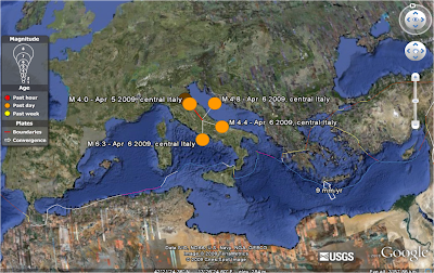
Sadly, the first news item I saw this morning was that an earthquake in Italy had killed at least 16 people. According to the BBC website, the death toll is now 27. The magnitude 6.3 earthquake struck the medieval city of L'Aquila in the early hours of this morning, causing many of the city's 70,000 residents to run out into the streets in panic. The age of the buildings meant that many of them were unable to withstand the quake, and the narrow mountainous roads are making rescue attempts more difficult.
The Google Earth screenshot below shows the area, with the USGS earthquakes layer enabled.
 More from the BBC here.
Also on the same news bulletin was that the Llaima volcano in Chile has been "spewing lava, ash and gas" overnight, causing many people from the surrounding area to be evacuated. As well as the danger from the eruption itself, melting snow is increasing the risk of mudslides, and volcanic ash has caused river levels in the area to increase. More here.
Sadly, the first news item I saw this morning was that an earthquake in Italy had killed at least 16 people. According to the BBC website, the death toll is now 27. The magnitude 6.3 earthquake struck the medieval city of L'Aquila in the early hours of this morning, causing many of the city's 70,000 residents to run out into the streets in panic. The age of the buildings meant that many of them were unable to withstand the quake, and the narrow mountainous roads are making rescue attempts more difficult.
The Google Earth screenshot below shows the area, with the USGS earthquakes layer enabled.
 More from the BBC here.
Also on the same news bulletin was that the Llaima volcano in Chile has been "spewing lava, ash and gas" overnight, causing many people from the surrounding area to be evacuated. As well as the danger from the eruption itself, melting snow is increasing the risk of mudslides, and volcanic ash has caused river levels in the area to increase. More here.
Tuesday, 31 March 2009
Mt Redoubt
Lots of volcanic activity over the past week or so at Mt Redoubt in Alaska... Nice image from the webcam here: Plenty of stories if you do a Google News search, and you can follow the ongoing activity via the Alaska Volcano Observatory site and on Twitter.
 Plenty of stories if you do a Google News search, and you can follow the ongoing activity via the Alaska Volcano Observatory site and on Twitter.
Saturday, 21 March 2009
Hunga Ha'apai
Lots of you were asking yesterday about the eruption of Hunga Ha'apai, the underwater volcano near Tonga, in the Pacific Ocean.
The Google Earth screenshot below shows the area, with the USGS earthquake overlay and the Smithsonian Global Volcanism overlay turned on...

A Google News search will bring up lots of articles, videos and photos... More here from the Times Online, and some superb images from The Big Picture.
The Google Earth screenshot below shows the area, with the USGS earthquake overlay and the Smithsonian Global Volcanism overlay turned on...

A Google News search will bring up lots of articles, videos and photos... More here from the Times Online, and some superb images from The Big Picture.
Subscribe to:
Posts (Atom)