I have just finished reading Map Addict by Mike Parker which (as well as making me realise I am not quite so obsessed with maps as I could be) was a brilliant read - full of interesting geography, history and stories that make you nod and smile in an "I know just what you mean" sort of way. Click on the picture for the Amazon link.
Back in Feburary, at half-term, it was far colder than it is now, and I was standing in a [very long] queue with a bunch of sixth form historians to go through super-sensitive metal detectors to get on a ferry to Ellis Island (woohoo - it must be named after you Miss!) and the Statue of Liberty. Partly, I was concerned about whether a certain student would be allowed through security with her very attractive leg splint and walking stick, but mostly I was hoping that the Battery Park Busker would not pick on me next... Luckily, he didn't - that leg splint and walking stick were far more interesting topics for the next song.
Several months later, I had some nice memories of the USA trip, and am hoping to go and visit again soon, but had forgotten all about the Battery Park Busker until I heard he'd been tracked down on YouTube and identified as Freddy Harrington. There are various videos of Freddy and his songs on YouTube, but I was particulary interested to find this one, in which he is interviewed, and he talks about the fact that he is a teacher, and about teaching his daughter about USA geography, and about our increasing connections with the rest of the world... If I go to New York again, and Freddy is there, I'll be sure to have a chat to him about some geography!
Attempts to manage the oil spill in the Gulf of Mexico are still ongoing and, in amongst all the election talk, there are various news articles about the impacts of the oil spill and the consequences for BP. The BBC's coverage is here.
Below is a screenshot from a nice Google Earth interactive map that allows you to compare the extent of the oil spill (which might not look that big when it's in the sea) to various cities around the world. Click on the picture to link to the site.
You may or may not be aware that Google StreetView is now pretty much nationwide. After a quick look at my house the other day (which was photographed on a Monday morning, because the bins are out...), I investigated Swanwick, and spotted Scott:
Explore where you live and see if you're a StreetView Star too! There might be a prize or two if you can find yourself on StreetView and send me a screenshot...
In the meantime, you might also find this article from The Telegraph interesting.
I've mentioned the fantastic Geograph site before, but if you've not visited for a while, it's well worth going back for another look because, as well as loads more great photographs, there is a new section with some very good games and activities...
Thanks to Lucy Rawe, who's just pointed out this excellent little site which allows you to calculate the "walkability" of your neighbourhood.
The idea is that walkable neighbourhoods are healthier, more environmentally friendly, more sociable, and have stronger local businesses... So, if you type in your address, WalkScore will plot the amenities local to you in a Google Map, and give you a score out of 100 for the walkability of your neighbourhood... Unfortunately, my neighbourhood is not very walkable at all; my score was an abysmal 7 out of 100 (although the shop next but one, and the pub four doors away are not listed). School scores slightly higher - 27 out of 100.
Click here or on the picture to read more about what the scores mean and what a "walkable neighbourhood" is, and then leave a comment to let us know your score!
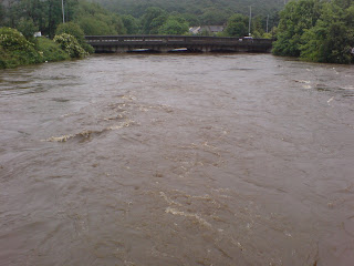
We might have had a lot of rain in Derbyshire, but West Yorkshire was officially the wettest county today... My dad's just sent me these photographs of the River Aire (just across the road from my old school!)
This picture shows a different view of the same bridge (from Yorksview) on a slightly calmer and drier day...
There's lots of coverage of the floods on the BBC website, and some interesting maps tracking the downpours.
Ooh - and this is post 200 since Geogtastic began on 11th December 2006! Thank you to our 8000+ visitors, and to all those people who point out things for me to write about on a regular basis! Here's to the next 200...
Below is the map that this morning's Yr 8 lesson started with... What do you think it shows?
This, and hundreds of other maps, are part of a fascinating project called Worldmapper... The maps, or cartograms, show 200 world territories, re-sized according to different variables.
The one below shows toy exports!
Click on the map to explore the Worldmapper site... Leave a comment and let us know about your interesting finds!
Mrs P found this interesting (if rather bizarre!) set of movies from the British Library today... Can you sort the fact from the fiction? Two of them are history ones, so that should keep H-Team happy!
While you're on the British Library site, check out the London: A Life in Maps exhibition they've got on at the moment.
In fact, while you're on the British Library site, have a good look round - there's loads of interesting stuff on there!